58703136
58739712
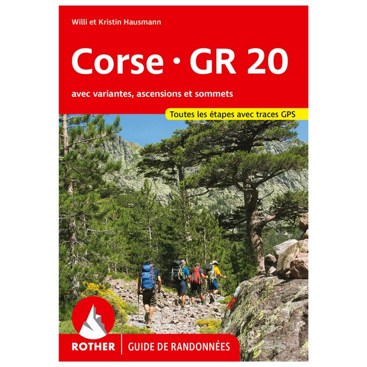
Corse GR 20
https://www.glisshop.co.uk/maps-guides/rother/corse-gr-2058739712
Rother
Men
Women
58739712
Rother's Corsica GR 20 hiking map details the famous route in 19 stages with downloadable altitude profiles, accommodation and GPS tracks.
https://glisshop-glisshop-fr-storage.omn.proximis.com/Imagestorage/imagesSynchro/0/0/aeee57af7f5872fce68b9338ae2ef1a2dadb6064_E24ROTHBIV472565_ROTH1057373_0.jpeg
https://glisshop-glisshop-fr-storage.omn.proximis.com/Imagestorage/imagesSynchro/0/0/00b6e587271993ab17a80a9e0685b81eba739e7f_E24ROTHBIV472565_ROTH1057373_901.jpeg
https://glisshop-glisshop-fr-storage.omn.proximis.com/Imagestorage/imagesSynchro/0/0/fb04c5f4bc65636c03ceb17c1f224e9909c90662_E24ROTHBIV472565_ROTH1057373_902.jpeg
https://glisshop-glisshop-fr-storage.omn.proximis.com/Imagestorage/imagesSynchro/0/0/49a2891ed9384ea58e423f7dc9f4e70731daa50d_E24ROTHBIV472565_ROTH1057373_903.jpeg
https://glisshop-glisshop-fr-storage.omn.proximis.com/Imagestorage/imagesSynchro/0/0/e62028031bd859f15f5321e2582a74c21a378c45_E24ROTHBIV472565_ROTH1057373_904.jpeg
InStock
15.21
GBP
15.21
GBP_VAT_royaume_uni
GBP_VAT_france
15.21
15.21
GBP
packs always have stock if there is a price
InStock
GBP_VAT_france_corse
15.21
15.21
GBP
packs always have stock if there is a price
InStock
GBP_VAT_espagne
15.34
15.21
GBP
packs always have stock if there is a price
InStock
GBP_VAT_italie
15.47
15.21
GBP
packs always have stock if there is a price
InStock
GBP_VAT_allemagne
15.09
15.21
GBP
packs always have stock if there is a price
InStock
GBP_VAT_pays_bas
15.34
15.21
GBP
packs always have stock if there is a price
InStock
GBP_VAT_belgique
15.34
15.21
GBP
packs always have stock if there is a price
InStock
GBP_VAT_suisse
13.71
15.21
GBP
packs always have stock if there is a price
InStock
GBP_VAT_suede
15.85
15.21
GBP
packs always have stock if there is a price
InStock
GBP_VAT_danemark
15.21
15.21
GBP
packs always have stock if there is a price
InStock
GBP_VAT_monaco
15.21
15.21
GBP
packs always have stock if there is a price
InStock
GBP_VAT_luxembourg
14.83
15.21
GBP
packs always have stock if there is a price
InStock
GBP_VAT_irlande
15.21
15.21
GBP
packs always have stock if there is a price
InStock
GBP_VAT_portugal
15.21
15.21
GBP
packs always have stock if there is a price
InStock
GBP_VAT_autriche
15.21
15.21
GBP
packs always have stock if there is a price
InStock
GBP_VAT_pologne
15.21
15.21
GBP
packs always have stock if there is a price
InStock
GBP_VAT_finlande
15.91
15.21
GBP
packs always have stock if there is a price
InStock
GBP_VAT_slovenie
15.21
15.21
GBP
packs always have stock if there is a price
InStock
CHF_VAT_france
17.18
17.18
CHF
packs always have stock if there is a price
InStock
CHF_VAT_france_corse
17.18
17.18
CHF
packs always have stock if there is a price
InStock
CHF_VAT_royaume_uni
17.18
17.18
CHF
packs always have stock if there is a price
InStock
CHF_VAT_espagne
17.33
17.18
CHF
packs always have stock if there is a price
InStock
CHF_VAT_italie
17.47
17.18
CHF
packs always have stock if there is a price
InStock
CHF_VAT_allemagne
17.04
17.18
CHF
packs always have stock if there is a price
InStock
CHF_VAT_pays_bas
17.33
17.18
CHF
packs always have stock if there is a price
InStock
CHF_VAT_belgique
17.33
17.18
CHF
packs always have stock if there is a price
InStock
CHF_VAT_suisse
15.48
17.18
CHF
packs always have stock if there is a price
InStock
CHF_VAT_suede
17.9
17.18
CHF
packs always have stock if there is a price
InStock
CHF_VAT_danemark
17.18
17.18
CHF
packs always have stock if there is a price
InStock
CHF_VAT_monaco
17.18
17.18
CHF
packs always have stock if there is a price
InStock
CHF_VAT_luxembourg
16.75
17.18
CHF
packs always have stock if there is a price
InStock
CHF_VAT_irlande
17.18
17.18
CHF
packs always have stock if there is a price
InStock
CHF_VAT_portugal
17.18
17.18
CHF
packs always have stock if there is a price
InStock
CHF_VAT_autriche
17.18
17.18
CHF
packs always have stock if there is a price
InStock
CHF_VAT_pologne
17.18
17.18
CHF
packs always have stock if there is a price
InStock
CHF_VAT_finlande
17.97
17.18
CHF
packs always have stock if there is a price
InStock
CHF_VAT_slovenie
17.18
17.18
CHF
packs always have stock if there is a price
InStock
EUR_VAT_france
17.9
17.9
EUR
packs always have stock if there is a price
InStock
EUR_VAT_france_corse
17.9
17.9
EUR
packs always have stock if there is a price
InStock
EUR_VAT_royaume_uni
17.9
17.9
EUR
packs always have stock if there is a price
InStock
EUR_VAT_espagne
18.05
17.9
EUR
packs always have stock if there is a price
InStock
EUR_VAT_italie
18.2
17.9
EUR
packs always have stock if there is a price
InStock
EUR_VAT_allemagne
17.75
17.9
EUR
packs always have stock if there is a price
InStock
EUR_VAT_pays_bas
18.05
17.9
EUR
packs always have stock if there is a price
InStock
EUR_VAT_belgique
18.05
17.9
EUR
packs always have stock if there is a price
InStock
EUR_VAT_suisse
16.12
17.9
EUR
packs always have stock if there is a price
InStock
EUR_VAT_suede
18.65
17.9
EUR
packs always have stock if there is a price
InStock
EUR_VAT_danemark
17.9
17.9
EUR
packs always have stock if there is a price
InStock
EUR_VAT_monaco
17.9
17.9
EUR
packs always have stock if there is a price
InStock
EUR_VAT_luxembourg
17.45
17.9
EUR
packs always have stock if there is a price
InStock
EUR_VAT_irlande
17.9
17.9
EUR
packs always have stock if there is a price
InStock
EUR_VAT_portugal
17.9
17.9
EUR
packs always have stock if there is a price
InStock
EUR_VAT_autriche
17.9
17.9
EUR
packs always have stock if there is a price
InStock
EUR_VAT_pologne
17.9
17.9
EUR
packs always have stock if there is a price
InStock
EUR_VAT_finlande
18.72
17.9
EUR
packs always have stock if there is a price
InStock
EUR_VAT_slovenie
17.9
17.9
EUR
packs always have stock if there is a price
InStock
/Hiking & camping/Maps - Guides
/Hiking & camping
brand - 46260864
211232 - 1
107027 - GLIS_NAME_TYPO_PRODUCT_32088
109123 - Sans
21127769 - 21127765
21127769 - 21127766
1323041 - 1386915


